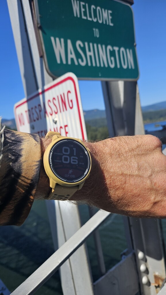
Day 1: 71 Miles
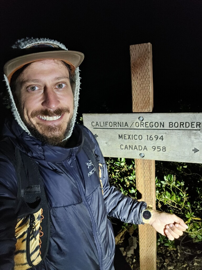
12AM start at California/Oregon border. Was misting rain when I started and continued almost the entire first day causing me to stay in the emergency poncho. Started without clear reroute for Petes Lake Fire 5 miles west of Elk Lake, but with a favorable weather forecast and 4 days before reaching the closure I set out on the attempt. Pushed 71 miles to 1.5 miles past my first cache at Dead Indian Memorial Highway, camped in South Brown Mountain Shelter- 9:42PM arrival. I decided to push to shelter due to weather. I was nervous about waking other hikers while still having my chores before bed, including processing my resupply I just scooped from Cache 1. There were three hikers there who fortunately were not asleep yet and okay with what I had going on and the time I told them I'd be waking up. I cached all of my cooking gear (including cast iron pan) and sleep gear in the first cache, allowing me to go light and far on the first day, and also making it mandatory that I made it that far.
Day 2: 55 Miles
3:40 AM start. Pushed past McLoughlin towards Crater Lake with the goal of being near Mazama Village highway for 60 miles. Stopped short and camped at the Union Peak Trail Junction. At some point during the day I started feeling shin splints developing in my legs. They would remain in my right leg for the rest of the trip. I got hailed on in the burnout section of the Oregon Desert before entering Crater Lake National Park. Camp was a cold night and I would oversleep my alarm and have my latest start of the trip at 4am the next day.
Day 3: 54 miles
After my 2019 experience attempting this where Mazama Village lost my resupply box I began relying on caches. This way I wouldn't worry about lost boxes, business hours, or extra off trail miles. I woke and pushed straight to the red line around Crater Lake. Eric had warned me of blowdowns through this section which began for me about halfway through this area. It looked like some early ones he may have encountered had been freshly cut. Everything was still quite wet making it feel like it was raining even though it was the clearest weather day yet. Once crossing the road where the rim trail rejoined the redline, it was maybe 9 miles downhill to my second cache at Hwy 138. I was completely out of food and water when I arrived early afternoon. I cooked my steak, switched out my trash and food and took some time to tend to blisters on my feet. I had 4 out of toes on one foot with blisters, and on e on the other. Also had one toenail I gave 24 hours before it would fall off. I expected the wet weather to do a number on my feet like this. The resupply rejuvenated me, along with passing areas that brought back memories of my failed attempt in 2019. I camped past where it took me over days to get to then, about 5 miles before Windigo Pass. Again didn't make it as far as I wanted but went to sleep early with the plan to make things up the next day. It began misting before camp so I found what looked like a nice dry spot under a tree to camp since I had no shelter.
Day 4: 61 miles
I slept poorly as the rain did come and hit me in the face all night. When I woke up I can feel intense pain in my kidneys and was worried I was getting sick. I was moving into the resort area of the trail which I remembered as being mellow for its terrain. Unfortunately it was still misting rain until noon. This was frustrating as the poncho wasnt even dry so it didn't make much sense even wearing it anymore. I just pleaded for the rain to stop. I moved well all day and knew I would be close to the reroute this evening. FKT helped guide me on which route was appropriate to take and I realized that although I had been maintaining a 10 mile lead on the record each day, I would likely lose that this evening/ the next day with the reroute. This was frustrating, but it just meant I had to start making my miles. On my way down from Diamond Peak to Cache 3 at Willamette Pass, I was doing so much hiker math, I didn't realize I was moving fast enough to show up 30 minutes early to the cache. This cache had a trash can nearby which meant I wouldn't have to return to clean it after. I ran to the dumpster at the ski resort after I was done cooking and packing and started up the trail to get to the reroute that evening. Everything was good until after 50 miles. The evening became later and I entered a badly burned section wityh sandy ground that made the trail almost indiscernible. A misty fog moved in making it worse. My miles slowed but I managed to make it two miles into the reroute and laid down and immediately passed out at the Many Lakes Trailhead.
Day 5: 59 miles
I was moving at 3:15. The reroute trail wasn't terribly bad and was even better after crossing the Cascade Highway after sunrise. I continued to maintain a good pace all day, determined to rejoin the PCT as quickly as possible. I stopped before Quinn Meadows Horse Camp at the end of the reroute and soaked my legs in the river for the first time. This helped tremendously and I also took some time for more blister care. At this point I felt the day was going quite well, but would soon find out just how wrong I was. After rejoining the PCT I was on the phone with my girlfriend when I stopped to plug in my headlamp so it would be ready for night hiking around North Sister. I realized that I somehow must have left my bag of electronics chord in camp that morning. Thankfully, I still had my battery bank and one USB-C chord for my phone. I realized because of timing I may need to push a 76 mile day to Santiam Pass to maintain my lead if I would have to hitch from a highway to get a new chord and have to contend with regular business hours. Plus it would be dark by the time I got to McKenzie Pass. This wasn't all though. The same time I realized the gear I lost, I checked my map and realized I had hiked over a mile down the wrong trail. I sprinted back down to the PCT, having done over two extra miles that day. I was so upset with myself. With the closure, I expected most thru-hikers had hitched around to Santiam Pass. Luckily I ran into a lone thru-hiker near South Sister named Beta. I asked him if he had a micro USB chord I could have and offered to mail him one of the fanny packs I make in return if he would give it to me. H was kind to give me his chord and saved me some continued stress from the whole afternoon. The rest of the evening went fine as I passed through the Obsidian area before North Sister at sunset. This is where I quit my attempt in 2019 and I reflected on how much I had learned and how far I've come since then. I moved through the dark up to the top of the last climb before it was all downhill. There was quite a long sandy downhill before the last mile of lava rocks to McKenzie Pass. I ran quickly down this entire section and thougt how great so many parts of the Oregon trail lend themselves to sustained running. This was also the first time I would start experiencing hallucination. The wet dirt in the middle of the rest of the dry trail made what seemed like endless Rorschach ink blots of images that my brain couldn't help but immediately identify as someone or something recognizable. This was especially tough because I had no choice but to look down while hiking in the dark. I thought the Dee Wright Observatory would be a good place to get some sleep in the middle of a lava field. When I got there, a cyclist was also there and it was quite windy inside. It sounded like two drunk people that also showed screaming just before my alarm went off. This would begin the deterioration of my sleep as my hips and legs would have so much pain that they would keep me up all night. I used the central pillar of the observatory to climb up with my arms, as my legs felt they were unable to stand up on their own.
Day 6: 57 miles
I started hiking around 3:40 am and quickly realized I should've at least camped at the cache just past the highway. That would've been the third mistake I felt I had made on day 5. Also, since I lost miles on the reroute and the 2 bonus miles in the wrong direction, I had only really hiked maybe 52 trail miles. I made it to the back of Mt Washington at sunrise and was eager to make it to Cache 5 at Santiam Pass, where I had cached a new pair of shoes. My feet were so dead by the end of the WA FKT, I thought this would maybe allow me to still be able to walk like a normal person when I was done this (wrong). I got to the cache maybe around 9 am, and did all the things, including switching into brand new socks and shoes. My feet felt so much better and I moved well from the cache uphill with happy feet for the moment. After three fingered jack I was slowed by blowdowns. Then I traversed a ridge that would end with a decent to Milk Creek by Mt Jefferson. The ridge was drier than I anticipated and between the shin splints and dehydration I had a few scary moments. I made up a lot of time on the run down to Milk Creek and while I drank several liters of water, I also soaked my feet in the creek. This would be the beginning of my auditory hallucinations. Just before sunset, the creek crossings somehow had what sounded like Nickelback playing near the water. Other crossings sounded like pop country. I continued on trying to get as close to Ollalie Lake as possible. I decided to camp at Forest Rd 4220, where comments listed a spring nearby. I forgot to scoop water before the end of the climb so this made sense as again, I had gone too long without water. After arriving and unsuccessfully searching in the dark for anything flowing, I laid down to pass out. Before I did, I made a loose plan for the remaining miles and sleep to stay on track for the record. I would wake up and hike the 48 to the cache, take a very short nap and then do the final 60 slack packed to the end.
Day 7: 61
When I woke up I realized I had to change my plan immediately. It was so terribly hard and painful waking and getting up that I knew if I were to sleep again, my body wouldn't let me get back up. I would push the 48 to the last cache at Frog Lake, spend an hour there and then push the final 60 to the end. A continuous 108 mile push was the new plan. As the sun came up past Ollalie Lake and I got a better look at the damage from the Lionshead Fire, I reflected on the events that caused me to wait this long to make it back to Oregon for this attempt and what it had led to. I never would have thought about the WA FKT if the fire hadn't happened....and I don't think I would've been as prepared as I was now without having the experiences I had in Washington. Just led me to think that even though sometimes don't go the way you plan them, they still can lead you to your goals. Early morning I was entering the Warm Springs Reservation and at 8 am I was attacked by bees, causing me to take off sprinting down the trail and getting stung 6-8 times. The worst part about this was the poor shin splints in my right leg that were tremendously aggravated and led me to limp down the trail for 2 miles to the nearest spring. I grabbed water and soaked my leg and thankfully the spring brought the leg back to life yet again. After this I was eager to get off the reservation and get to the cache. I stopped once more at Warm Springs River to soak my legs again. When I got to Nation Forest Road 42, there was a trail angel named Carbs doing trail magic. I was down to a bag of gummy worms and he offered me a pancake and a coke. We both made each others days with each others stories. I had a shot of rum and took off towards Frog Lake. At this point I finally got back into service and my girlfriend got in touch with me and asked if everything was okay with my Garmin. It hadn't updated for hours and I hadn't noticed. Since I could no longer charge or use my Coros I panicked and started troubleshooting. I started a strava and gaia track on my phone while I had service and screenshotted the lines connecting my day to this point before I decided to stop the track and restart it. I was doing this all on the move and decided I couldn't meaningfully mess with it anymore until I hit my designated stop at the Frog Lake cache. Later I realized that there was probably nothing wrong with the track until I messed with it and that it probably just hadn't updated because I had been in the trees all day in Warm Springs and the Hood National Forest. I got to Frog Lake at 6:15 pm and cooked my last meal, packed my food for the last 60 and cached absolutely anything I wouldn't need for the last 60 miles. I spent longer than planned at the cache, but it was a busy day and I didn't want to leave until I felt ready. I left at 7:30 pm with my body feeling shaky and talked to myself about balancing my personal safety with the goal of getting the record. I decided I would walk the first two big climbs and save the hard running for the later miles. I also had spent so much time dealing with the Garmin that I had to charge those two things before my headlamp, so I started off into the dark with a dead headlamp. This led to several river crossings that I'd show up to holding my cell phone light. Some of them so confusing in the dark that the idea of not getting the record finally first crossed my mind.
Day 8: 46.7
I kept pushing through the dark, delirious and constantly hallucinating. I took several hard falls in the dark and had to fight off falling over from being so tired. Without my Coros watch, I had no way to accurately gauge my current speed. I began repeating a hiker math equation on my phone on an almost hourly basis. I would divide the number of miles to the bridge by the number of hours left to the record to find out what speed I should move at to be on record pace. Then I would guess or push to what I though that was. This mostly meant trying to run everything. The miles felt tremendously hard and slow in the night hours. As the sun came up, the trail chilled out and the running became more sustained. Eventually I had such long running efforts that I knew I had finally made myself a little bit of a cushion. I kept pushing on with about a marathon to go at sunrise and just a few small climbs to go (which I would try to run all of). At Wahtum Lake I took another wrong turn that led to a bonus climb and had to sprint back down the trail and reconnect to the PCT. After this I paid closer attention to the map and every trail junction. The running continued all morning and I knew my legs would be shot, but they held together all the way to the bridge. The last 10 miles felt like an eternity and I barely wanted to stop for water. I finally stopped one last time and grabbed two liters before I passed out and continued running the whole way down to the bridge, where I arrived at 1:05 PM
I will be making a recap video for this effort where you can find here: