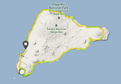
On May 31st 2014 I completed a solo loop around Rapa Nui (or Easter Island): 65.05 kms, 9hrs 5mins. And I think it stands as 'unsupported' - unless you count the little black dog who accompanied me for about 20miles - and the 2 glasses of rainwater I gratefully accepted along the way!!
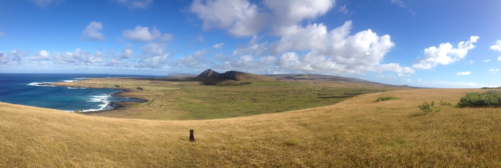
PHOTO 1: View of the southern coast of Rapa Nui and the site 'Tongariki' - in the middle of the pic is the crater of Rano Raraku (moai carving centre) - and also, in the foreground, my canine companion.
It was an incredible run dominated by views of the South Pacific, dramatic coastlines, volcanic craters, island dogs, monumental archaeology and much more!
The route I took was rocky, exposed to the elements and full of surprises. I had chosen to follow the course of an ancient footpath after doing some research and discovering a reference to the 'Ara Mahiva' - a trail that followed the coast of the island.
Like everyone else, I'm posting here so that others visiting the island have a few reference points and an idea of what to expect - if you plan to do the same run, or maybe a hike/ run along a section of the coast. And I'm sure my time can be improved upon - greatly!!
What to expect:
Terrain - Be prepared to spend most of your time picking out a path through volcanic lava fields of broken up black basalt! There are some sections where picking up a dirt road or the main asphalt road is necessary, but overall you can stay fairly close to the coast. Very little 'single track'. Did I mention it's rocky?! Take time to warm up and find your stride to save your ankles!
Access: The coast was accessible in most places, most people are fairly relaxed and are happy to see you out exploring - as long as you act with respect for residents (past & present), and the traditions and history of the island's culture. There was only one section on the north/easterly coast where I could see a house and hear dogs! Some sections are also too rocky to run over, especially on what is known as 'the south coast road' - which is where I picked up the main road for a few miles. The majority of people live in the village but occasionally you will see cowboys out tending to horses and cattle, or come across a single house built outside the village.
Weather - In May the daily average temps are fairly reasonable (around 20 degs C) - and the weather was kind to me but it can be very windy and wet in June/July/August - and dip to 15 degs C - freezing... In the middle of summer - Dec/ Jan/ Feb it can also be fairly hot (25+ degs C) and humid. Plan accordingly. Typically throughout the year squalls blow in from the ocean bringing short bursts of intense rain - but five minutes later the sun will be shining again!
Water - There are very few places to access water - unless you have local knowledge ahead of time on the whereabouts of fresh water springs - which are actually often in a sea water bay! I was lucky enough to meet people who gave me the couple of glasses of roof catchment rainwater - that was the only support I had on the day. You might plan to stash water the day before at around the half way point. I carried 2.5 litres in two bottles - unfortunately I didn't have a reservoir/ bladder with me. Really I could have done with more water...
Route description:
I ran in a clockwise direction around the island, starting and finishing at a site known as 'Tahai' in the main village of Hanga Roa.
Basically there are three main geographical areas of the island, determined by the three volcanic events that created the island's triangular looking shape.
It's fairly logical to break the run up in to those three sections, by volcano name:
1. Terevaka (actually the highest point on the island, 507m, but you run around it).
2. Poike - rolling grass land over the oldest area of the island.
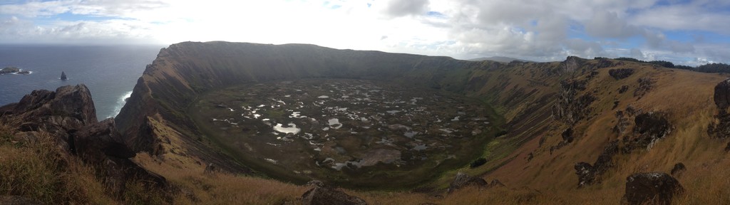
3. Rano Kau - steep climb up to sea cliffs that look down over two out islets - serious exposure and views over the fresh water & reed filled crater.
PHOTO 2: *NB! Not possible to run the entire rim of this crater due to erosion and the boundary of the World Heritage Site but you can run the westerly edge, which is where this pic was taken from.
Each section of the Ara Mahiva route consists of a climb and descent - the final one to Rano Kau (pictured above) being the highest point of the day - 347 metres.
Unfortunately when I reached the top of the Poike Penninsula I followed a cow trail away from the coast and so actually cut my run short. I think the total would have been closer to 70kms if I had hugged the coastline.
For a more in depth description of the run please see the post: www.longrunergy.com/2014/06/11/ara-mahiva-run/
Feel free to message with any questions if you are planning a trip to the island.
Iorana and happy trails!
Susie