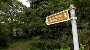
The East Munster Way is a 70km linear walking route of considerable variety, from riverside paths to woodland and from open mountain moorland to quiet country roads and it is part of the European E8 route. It starts in the town of Carrick-on-Suir, at the south east extremity of County Tipperary, and follows the River Suir upstream.
The Suir, held ... Read more
The East Munster Way is a 70km linear walking route of considerable variety, from riverside paths to woodland and from open mountain moorland to quiet country roads and it is part of the European E8 route. It starts in the town of Carrick-on-Suir, at the south east extremity of County Tipperary, and follows the River Suir upstream.
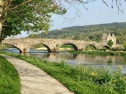
The Suir, held by some to be the second-longest river in Ireland, is majestic and slow-moving at this point, overlooked by old castles and churches, and home to otters and herons. At the pretty village of Kilsheelan, the route crosses into County Waterford and ascends into the foothills of the Comeragh Mountains. It soon descends again to follow the Suir into the vibrant county town of Clonmel, which has a lot to offer those who linger.
Leaving Clonmel the Way crosses a western outlier of the Comeraghs to reach the northern flanks of the Knockmealdown Mountains where it meanders westwards with spectacular views before descending to reach the town of Clogheen.
Terrain consists mainly of forestry tracks, riverside tow paths and quiet tarmac roads: some off-road paths may be a little overgrown. Total aggregate ascent over the route is less than 1700m, but there are some short, steep climbs.
https://www.sportireland.ie/outdoors/walking/trails/east-munster-way
Read less 
Comments
A little ERROR near the start that can be clearly seen above. After that route is correct. Note, sign posting is not great so a map and/or GPS is required.
East-West Mapping is Recommended i.e..
https://eastwestmapping.ie/product-category/munster/
Knockmealdown
Comeragh