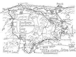
SALT is a 350ish mile circuit created by Matt Kirk using the Appalachian Trail, Bartram Trail, Chatooga River Trail, Foothills Trail, Palmetto Trail, Art Loeb Trail and the Mountains-to-Sea Trail along with a few connecting trails/ roads through Brevard. The loop is complete except for a short section from the Palmetto Trail to DuPont State Park. Land was recently acquired by DuPont to connect the circuit but is in the beginning stages of building the trail. Here is a write up from Blue Ridge Outdoors Magazine:
"Accessibility to public lands in the Southern Appalachians has improved the lives of millions, myself included. After eight years of calling this region my home, I’ve grown physically, mentally and spiritually stronger with access to nearby trails. Not only do these paths lead to improved health, but they also help to protect the environment and foster economic growth.
Now, a new 350-mile trail circuit could benefit the health of both the people and the economy of the region. The Carolina Mountain Land Conservancy, a western North Carolina land trust, is working to protect and make public the final link of the Southern Appalachian Loop Trail (SALT).
In the summer of 2012, I had the privilege of thru-hiking SALT, which incorporates sections of the Foothills, Bartram, Appalachian, Mountains-to-Sea and other regional trails. I chose to start the SALT from Jones Gap State Park in the Mountain Bridge Wilderness Area of South Carolina. I hiked in a clockwise direction towards Georgia along the Foothills Trail, which is unparalleled in its lushness and abundance of waterfalls cascading down from the Blue Ridge Escarpment. This section is deceptively rugged and remote, but swimming holes and wildflowers more than make up for its adversity.
After crossing the wild and scenic Chattooga River into Georgia, the SALT hops onto the Bartram Trail and follows in the 240-year-old footsteps of famous naturalist William Bartram as it leaves the foothills and ascends ever higher into the balds of the Nantahala Mountains. Along the way, hikers find convenient provisions in Clayton, Ga. and across the state line in Franklin, N.C. Soon, the route joins up with the popular Appalachian Trail and continues north into the international biosphere reserve of Great Smoky Mountains National Park.
From Clingmans Dome, the highest peak in Tennessee, the SALT leaves the A.T. for the Mountains-to-Sea Trail and heads eastward down into Cherokee, N.C., which provides another resupply opportunity and immersion into a culture that precedes all others in calling this land home. The trail once again scrapes the clouds at over 6,000’ in elevation amid the high coniferous forests of the Great Balsams.
A right-hand turn on the renowned Art Loeb Trail brings the sojourner to the Bracken Mountain Trail and through the blossoming outdoor city of Brevard, N.C. After a short road walk through the French Broad River valley, the SALT enters into the woods of DuPont State Recreational Forest and makes its way towards a final ascent of the Blue Wall. Here, nearly a stone’s throw away from the finish at Jones Gap State Park, public access comes to a screeching halt.
It’s disheartening to think that such a perfect loop could be blocked by such a small section of privately owned land. Fortunately, the Carolina Mountain Land Conservancy has been pursuing the conservation and public access of natural land between DuPont and the Mountain Bridge Wilderness Area to enable a connecting trail. When this project is complete, the Southern Appalachians will be blessed with another wilderness corridor and long-distance hiking adventure"
https://www.blueridgeoutdoors.com/go-outside/hiking/grain-s-l-t-southern-appalachian-loop-trail-almost-reality/
Another article about the circuit:
http://appvoices.org/2014/04/09/connecting-the-dots-of-the-southern-appalachian-loop-trail/
Seth Orme wrote a blog on his thru-hike of SALT:
https://www.sethorme.com/blog/salt-part-one
https://www.sethorme.com/blog/salt-post-two
https://www.sethorme.com/blog/salt-part-3